
Leg Up is located just south of Ballantyne (S. Charlotte NC) in Fort Mill / Indian Land SC. Serving our local Charlotte communities near Waxhaw, Marvin, Matthews, Pinevile and South Carolina communites of Rock Hill, Tega Cay. From Fort Mill/Tega Cay: |
From Charlotte: I-485/HWY 521 South (Ballantyne - exit #61B) Horse Riding Stables near me - the neighborhoods we serve: |
|
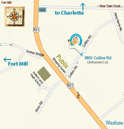
| note: some GPS devices are not always 100% accurate on country roads. It may be helpful to take this map along too! | From Blakeney Shopping Center: 9870 Read Road: Take Audrey Kell Rd. to HWY 521. Turn LEFT. Hwy 521 South for 5.2 miles. to Collins Rd.(Publix Shopping Center on Left). Turn LEFT. Take Collins Rd. 1.2miles to Johannes Ln. (gravel rd - look for Leg Up Sign). Turn LEFT. Park at the main barn. |
|
Leg Up Equestrian
GPS Address:
6201 Johannes Rd.
Fort Mill, SC 29715
